| Bog River
State-owned
lands along the Bog River between Lows Lower and Upper dams and at Lows Lake offer
canoeists a unique opportunity to enjoy over 14.5 miles of unencumbered scenic
waters with only one short carry around Lows Upper Dam. For the more adventuresome,
a carry of approximately 3.5 miles from the west end of Lows Lake to the Oswegatchie
River will be rewarded with an approximately 16-mile trip down that river to Inlet,
with only a short carry above High Falls. Numerous beaver dams occur around High
Falls. To add to the serenity of the area, motorized boats are prohibited between
the two dams.Primary public access to the area is by a short gravel road off
State Rt. 421 to Lows Lower Dam, where a canoe may be launched. This road may
be gated in the spring to protect it during frost-out. Alternate canoe access
is available at Horseshoe Lake Outlet. 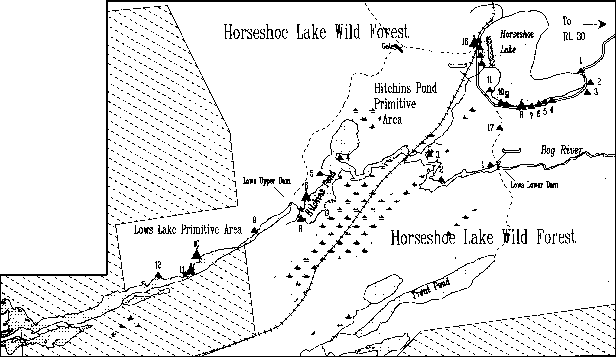 |
Lake Lila
The 7,215 acre Lake Lila Primitive Area is in the Town
of Long Lake. Lake Lila is the chief feature of this area. Covering about 1,400
acres, the lake offers superb opportunities for canoeing and camping under essentially
wilderness conditions. Visitors will find giant white pines along the shoreline
of Lake Lila, several natural white sand beaches, and seven islands in the lake.
Camping is permitted on the four larger islands. The area surrounding Lake Lila
is considered excellent wildlife habitat. Fishing in Lake Lila includes brook
trout, lake trout, landlocked salmon, smallmouth bass and yellow perch.To reach
the Primitive Area, take State Route 30 to Hamilton County Route 10, turn west
and proceed about seven miles to an improved gravel road (Lake Lila Rd.) This
intersection is marked with a DEC sign. Turn left and proceed about six miles
to a 30-car DEC parking area. Overnight parking is permitted. Parking of trailers
is prohibited. 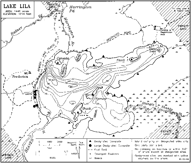 |